Now hiring | Multiple roles
View active rolesNow hiring | Multiple roles
View active roles
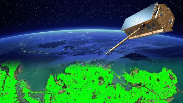
InSAR - Satellite based ground and structure deformation monitoring made simple.

Atlas-InSAR™ is our in-house InSAR solution for remote monitoring of ground deformation with millimetric accuracy.
Radar satellite interferometry (InSAR) represents a non-intrusive surveying method renowned for its ability to precisely measure millimeter-scale movements of terrain features across expansive regions, spanning both urban and rural landscapes.
This technique capitalizes on synthetic aperture radar (SAR) imagery captured by satellite sensors.
.
Atlas-InSAR™ harnesses raw satellite data, meticulously processed from satellite constellations, to furnish comprehensive time-series data on ground motion, boasting an impressive density of up to 20,000 points per square kilometer.
.
Whether employed independently or in tandem with traditional instrumentation, Atlas-InSAR™ offers unparalleled insights into your site or infrastructure, all without the need for ground-based installations.
Delve into the depths of historical data and uncover invaluable insights with Atlas™ InSAR solution. Harnessing the extensive SAR data archive dating back to 1992, Atlas -InSAR™ enables retro studies, offering a unique perspective on ground movements over time.
By tapping into this reservoir of information, you gain a deeper understanding of past vulnerabilities, ensuring your construction designs are finely tuned to prevailing conditions. With Atlas-InSAR™, embrace the power of retro studies to elevate your project's performance while safeguarding against potential claims.

Atlas-InSAR™ harnesses the power of high-resolution satellite imagery, delivering results with an impressive resolution down to 1m x 2m in the best conditions and a density of up to 20,000 Pts/Km2, even across expansive territories. This groundbreaking capability grants you access to an unprecedented wealth of information, facilitating in-depth analysis and understanding of your site's dynamics, irrespective of its scale, infrastructure, or urban context.
Consider the implications of dewatering activities, which can exert substantial influence over considerable distances. Thanks to Atlas-InSAR™ measurements, you can precisely delineate the perimeter at risk, mitigating the potential challenge of losing reference points for ground instruments. With Atlas-InSAR™, you gain the ability to vigilantly monitor ground movements, detecting even the slightest fluctuations with precision. Armed with these insights, you can swiftly implement corrective measures, optimising your project's performance with timely actions.
ATLAS™ InSAR offers an affordable complement and/or alternative to traditional ground deformation monitoring methods. By providing measurement layers of many thousands to a few million measurement points (depending on the surface), ATLAS™ enables you to gather more data in a shorter time frame compared to precise leveling, which monitors around 100 points per day in a specific area.
Moreover, ATLAS™ can provide more than 20,000 measurement points per km2 in urban environments, making it an ideal solution for large-scale projects. By deploying a combination of complementary technologies such as precise leveling, Automatic Total Station, and InSAR, you can significantly lower the cost of ground deformation monitoring while delivering richer information.
With ATLAS™, you can optimise your project's budget without sacrificing accuracy or precision.
Beyond Monitoring™ is our web based delivery platform for all of your projects. With an architecture optimised for “big data”, visualisation and analysis of millions of data points is smooth and intuitive.
Being able to smoothly handle a few million data points from Atlas-InSAR was one of the non-negotiable specifications of the platform and the result is above expectations.
One of our projects in Auckland is generating 7,600,000 data points every 11 days and has been running for 40 months. Navigating this substantial database to locate and analyse critical areas is straightforward.
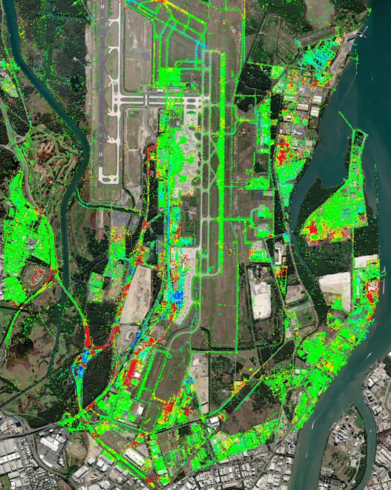
Atlas-InSAR™ is a versatile tool that can be applied to various environments, from urban to rural settings, to monitor almost any type of asset, including buildings, airports, ports, dams, roadways, railways, and mines.
One of the key strengths of Atlas-InSAR™ is its ability to monitor settlement induced by underground excavation and dewatering for tunnel construction, mining, and other projects. Its capacity to monitor large areas simultaneously with high density and accuracy is unmatched, making it an invaluable tool for these industries.
Given its exceptional performance, Atlas-InSAR™ is rapidly becoming a standard in ground and structure deformation monitoring, empowering you with the insights you need to make informed decisions and optimise your project's performance.
No wonder Atlas InSAR is becoming a standard in ground & structure deformation.
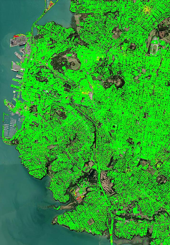
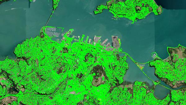
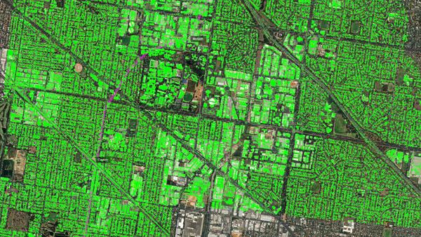
Sixense Oceania pioneers the integration of AI-based advanced data analytics with Atlas-InSAR for comprehensive soil monitoring and flood impact assessment. Atlas-InSAR's SAR technology offers unparalleled precision in tracking soil movements, while AI-driven analytics unlock deeper insights from the vast datasets generated.
This integrated approach enables early detection of soil risks and proactive mitigation strategies for diverse projects, from urban development to environmental conservation. Moreover, our solution extends to assessing flood impacts, crucial in the face of climate change-induced extreme weather events.
In New Zealand, Sixense Oceania empowers clients to make informed decisions, fostering a safer and more resilient Auckland for future generations.
Around Auckland, we are already starting to see higher temperatures, increased drought, more intense rainfall events and sea level rise. We expect more change over the next 100 years. Also Auckland Council has declared a climate emergency and established a plan to prepare Auckland for the impacts of climate change
The Auckland area is subject noticeable ground movements and to analyse the impact of the climate on the ground deformation, Sixense as provided Atlas- InSAR high resolution data over the extended metropolitain Auckland.
The delivery was completed by advanced data analytics to extract the important information form this "big data" set.
Measurement Pts
Surface
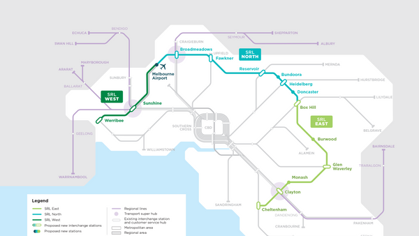
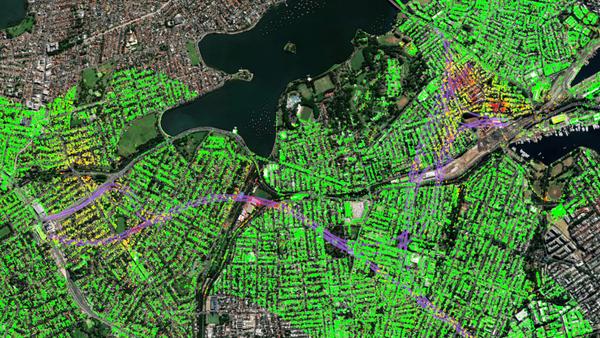
The Suburban Rail Loop (SRL) is an orbital line of the rail tunnel network of Melbourne, which will traverse suburbs 15–25 kilometres from the Central Business District (CBD) along an approximately 90 km route. Stage 1 between Cheltenham to Box Hill is underway to construction.
Sixense is providing extensive baseline monitoring over the tunnel alignment and surroundings with Atlas- InSAR medium and high resolution. To complete the monitoring scheme, a set of Artificial Corner Reflectors (ACR) has also been installed to provide measurement data, either on green field where traditional InSAR processing is more limited, or on critical areas/points.
Measurement Pts
Duration
Artificial Corner Reflectors

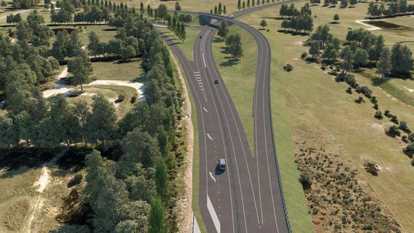
The Muswellbrook Bypass is a critical infrastructure project planned along the New England Highway in New South Wales. It is designed to improve travel times, enhance freight efficiency, and increase road user safety. The bypass will divert through traffic away from Muswellbrook, reducing congestion caused by intersections and buildings close to the existing highway.
Sixense has been engaged to provide advanced InSAR monitoring for the project. This monitoring enhances safety, supports the assessment of historical and potential ground movements, and ensures that construction proceeds within acceptable tolerances, particularly in areas influenced by nearby mining activity.
InSAR measurement points
high-resolution SAR images
WestConnex is a 33-kilometre predominantly underground motorway scheme in Sydney. The full project is divided in seven diffrents packages with construction staged over a decade.
Sixense is providing Atlas-InSAR monitoring at high resoluton over the span of the projects.
Measurement Pts
Duration

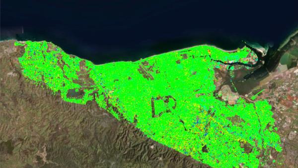
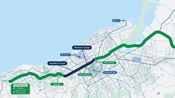
The 10.5 km Torrens to Darlington (T2D) tunnel project is the final piece of one of Adelaide’s most important transport routes, the North-South Corridor (NSC).
In order to gain a clearer understanding of the initial conditions, the Department of Infrastructure and Transport (DIT) enlisted Sixense to conduct historical ground deformation monitoring along the tunnel alignment. At the end, we ended up analysing the entire Adelaide Basin. This provided the team with invaluable data for their geotechnical analysis.
Surface analysed
Historical period
InSAR measurement points (PSI)
Measurement layers
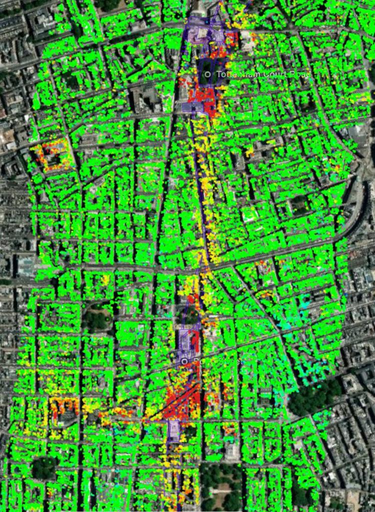
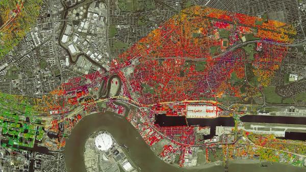
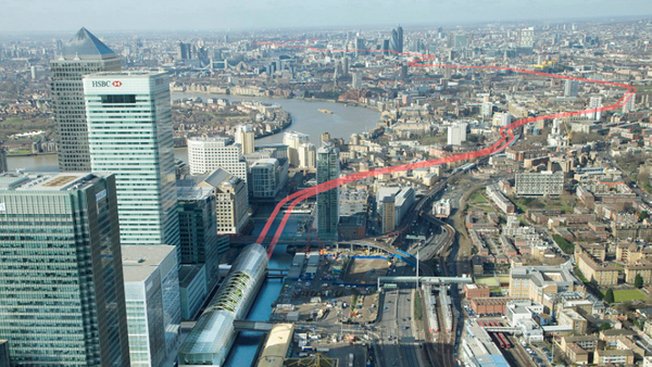
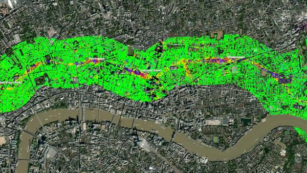
Crossrail (The Elisabeth Line) is a 117-kilometre railway that traverses London from East to West. The construction phase of the project began in 2009 with an estimated cost in excess of £17 billion. The main challenge, for which the ATLAS InSAR technique was pivotal, was monitoring the 21km of twin tunnels running from Paddington to Stratford and Canary Wharf below the city.
Crossrail is the first construction project actively using InSAR as a technique to reduce monitoring costs. ATLAS InSAR monitoring was performed before and during the construction of the tunnels and is still ongoing to analyse residual settlement. The study area monitored includes a corridor 2km wide over the tunnel alignment, covering a total area up to 36 km2.
Measurement Pts
Duration
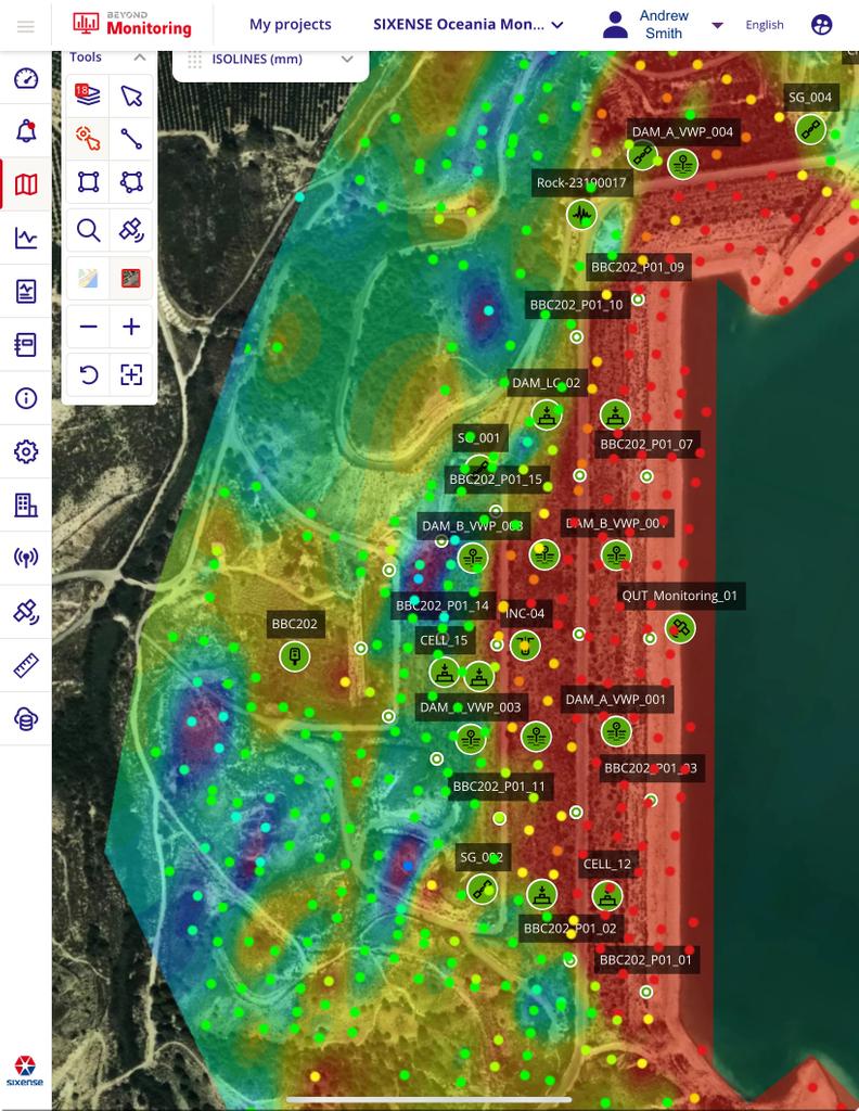
The Darlington Upgrade Project, part of South Australia's ambitious North-South Corridor initiative, is transforming approximately 3.3 km of Main South Road. This significant redevelopment aims to enhance the region through reduced travel times and increased freight transport efficiency.
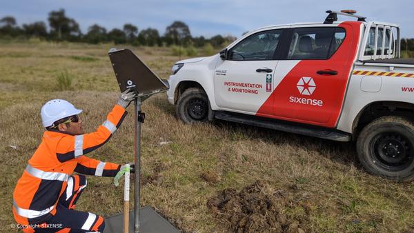
At Sixense, we have been instrumental in providing sophisticated monitoring solutions for a segment of this project. Our role involved delivering an array of monitoring sensors and a data acquisition system, encompassing tiltmeters and Cyclops ATS products. These were deployed by our clients on the ground, with our experts offering remote assistance for seamless installation and operation.
Further enriching our monitoring capabilities, we conducted an Atlas-InSAR satellite radar interferometry study over an expanse of around 3.4 km². This advanced technique allowed us to meticulously track deformation across the project area, enabling the collection of vital data on background movements and settlements.
Cyclops (ATS)
Tiltmeters
InSAR measurement points
Prisms